
All-In-One Offline Maps
In-app purchases
4.4star
55.6K reviewsinfo
5M+
Downloads

PEGI 3
info


About this app
No advertisements ~ No data sharing & monetization ~ No analytics ~ No third party libraries
Bored to wait for maps to display? Use All-In-One OfflineMaps! Once displayed, maps are stored and remain available, quickly, even with no network access.
• Want more than just roads on your maps? You will find what you need here;
• Used to go to places with poor network coverage? Everything will stay available;
• Used to go abroad? You won’t be lost anymore;
• Have a data allowance limit? It will reduce your usage.
★★ Maps ★★
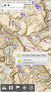
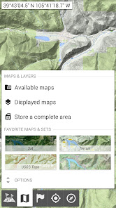
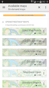
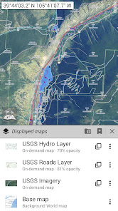
A lot of maps are available, including classical road maps, topographic maps, aerial (satellite) maps and various layers that can be added over any maps: OpenStreetMap (Roads, Topo), USGS National Map (Hi-res topo, Aerial imagery), Worldwide Military Soviet topo maps, etc.
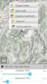
• All maps can be stacked in layers, with precise opacity control;
• Select and store large areas in few clicks;
• Stored space is clear and can be easily deleted.
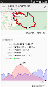
★★ Display, store and retrieve unlimited placemarks ★★
You can add various items on the map such as waypoints, icons, routes, areas and tracks.
You can easily manage them using the powerful SD-Card Placemarks Explorer.
★★ On-map GPS Location & Orientation ★★
Your real location and direction are clearly displayed on the map, which can be rotated to match your real orientation (depends on device capabilities).
Easy turn on/off to save battery.
And also:
• Metric, imperial and hybrid distance units;
• GPS Latitude/Longitude and grid coordinate formats (UTM, MGRS, USNG, OSGB Grid, Irish Grid, Swiss Grid, Lambert Grids, DFCI Grid, QTH Maidenhead Locator System, …);
• Ability to import hundreds of coordinate formats from https://www.spatialreference.org;
• On-map grids display;
• Full screen map view;
• Multi-touch zoom;
• …
★★ Need more? ★★
If you are a real adventurer, try AlpineQuest Off-Road Explorer, the complete outdoor solution based on All-In-One OfflineMaps, loaded with a powerful GPS Track Recorder and more: https://www.alpinequest.net/google-play
Bored to wait for maps to display? Use All-In-One OfflineMaps! Once displayed, maps are stored and remain available, quickly, even with no network access.
• Want more than just roads on your maps? You will find what you need here;
• Used to go to places with poor network coverage? Everything will stay available;
• Used to go abroad? You won’t be lost anymore;
• Have a data allowance limit? It will reduce your usage.
★★ Maps ★★
A lot of maps are available, including classical road maps, topographic maps, aerial (satellite) maps and various layers that can be added over any maps: OpenStreetMap (Roads, Topo), USGS National Map (Hi-res topo, Aerial imagery), Worldwide Military Soviet topo maps, etc.
• All maps can be stacked in layers, with precise opacity control;
• Select and store large areas in few clicks;
• Stored space is clear and can be easily deleted.
★★ Display, store and retrieve unlimited placemarks ★★
You can add various items on the map such as waypoints, icons, routes, areas and tracks.
You can easily manage them using the powerful SD-Card Placemarks Explorer.
★★ On-map GPS Location & Orientation ★★
Your real location and direction are clearly displayed on the map, which can be rotated to match your real orientation (depends on device capabilities).
Easy turn on/off to save battery.
And also:
• Metric, imperial and hybrid distance units;
• GPS Latitude/Longitude and grid coordinate formats (UTM, MGRS, USNG, OSGB Grid, Irish Grid, Swiss Grid, Lambert Grids, DFCI Grid, QTH Maidenhead Locator System, …);
• Ability to import hundreds of coordinate formats from https://www.spatialreference.org;
• On-map grids display;
• Full screen map view;
• Multi-touch zoom;
• …
★★ Need more? ★★
If you are a real adventurer, try AlpineQuest Off-Road Explorer, the complete outdoor solution based on All-In-One OfflineMaps, loaded with a powerful GPS Track Recorder and more: https://www.alpinequest.net/google-play
Updated on
Safety starts with understanding how developers collect and share your data. Data privacy and security practices may vary based on your use, region, and age. The developer provided this information and may update it over time.

No data shared with third parties
Learn more about how developers declare sharing

This app may collect these data types
Personal info

Data is encrypted in transit

You can request that data be deleted
Ratings and reviews
4.5
53.1K reviews

Michael Reschauer
- Flag inappropriate
September 11, 2025
Perfect map program for me. Lead ne to many great nature spots in Europe and in the US. just read the map and plot your path. I also use it to document points of interest in cities with the picture waypoint feature.

Rich West
- Flag inappropriate
August 27, 2025
Wow, this app is incredible. I am just learning what it can do and I am already blown away by the features. For example, to be able to change the contrast and brightness of maps so that you can read them in direct sunlight. Wow!
11 people found this review helpful

Andrew Thoms
- Flag inappropriate
August 15, 2025
offline maps is amazing to use! very easy and used for work in the bush, adventures into the mountains and hunting. great asset to have.
28 people found this review helpful
What’s new
The complete list is available in the changelog inside the application.
3.17
• A small eye icon is visible in the placemarks explorer for items currently displayed on the map;
• Added SK32 coordinates systems;
• Improved DFCI grid;
• Online account: added a button in case of forgotten login or password;
• And more
3.17
• A small eye icon is visible in the placemarks explorer for items currently displayed on the map;
• Added SK32 coordinates systems;
• Improved DFCI grid;
• Online account: added a button in case of forgotten login or password;
• And more
App support
About the developer
AMBROSI CAMILLE FRANCOIS
CALLE MERCE RODOREDA 80
46530 PUÇOL
Spain
+34 689 63 32 20


