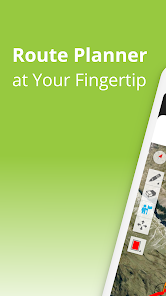
TouchTrails: Route Planner
Contains adsIn-app purchases
3.8star
1.64K reviewsinfo
100K+
Downloads

PEGI 3
info


About this app
TouchTrails is an easy-to-use route planner for all your outdoor adventures . Simply trace your routes on the map with your finger to get accurate distance information and detailed elevation profiles.
Plan routes for your next bike ride or multi-day hiking adventure. Then follow along with turn-by-turn voice navigation.
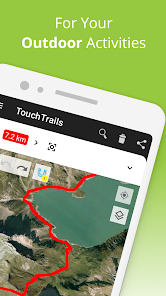
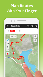
Plan and customize your routes
Draw routes anywhere with your finger. Snap to road keeps you on track, but you can also go completely off-road. TouchTrails gives you the flexibility to create routes that fit your needs. Split routes, erase parts or connect them.
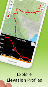
Measure distance and elevation
Accurate distance measurements and detailed elevation profiles help you understand how far and how high your adventure will take you.
Add and edit waypoints
Enhance your map with highlights, tips and points of interest with waypoints. An extensive library of waypoint icons lets you customize your map.
GPS Tracker
Record your adventures with the GPS tracker. Save, edit or share your journeys with friends.
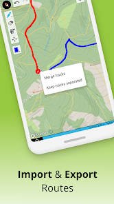
GPX Viewer
Found the perfect trail on the web? Import GPX files from anywhere. Navigate along the routes, measure distances and analyze elevation profiles. Edit them as you wish.
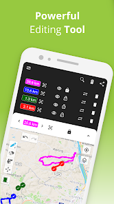
Multiple routes on one map
Your are not limited to a single route on a map. TouchTrails allows you to view multiple routes simultaneously on one map. The flexibility of TouchTrails also allows you to combine and connect routes from different sources.
Share routes
Send your routes to friends and share your adventure with them.
TouchTrails is the perfect route planning, GPS tracking and navigation app for all types of outdoor adventures, including:
• Running, walking and hiking
• Cycling and mountain biking
• Motorcycling
• Overlanding
• Skiing
• Mantrailing
• and many more!
TouchTrails Premium
Upgrade to TouchTrails Premium for even more extra power!
• Snap to road
◦ TouchTrails instantly locks onto any road, bike path or hiking trail
• Turn-by-turn Navigation
◦ Warns you when you leave the route
◦ Turn-by-turn directions via audio
• Access 100+ symbols for waypoint customization
• Save an unlimited number of routes
• Export GPX files
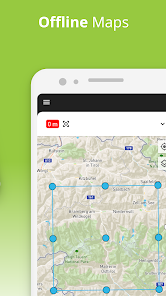
• Offline maps to use TouchTrails even when the internet is unavailable or unreliable
For support and tips, please visit https://www.touchtrails.com/docs/user-guide
Install TouchTrails now and pave your path to unforgettable adventures! 🌲🚴🏃
Plan routes for your next bike ride or multi-day hiking adventure. Then follow along with turn-by-turn voice navigation.
Plan and customize your routes
Draw routes anywhere with your finger. Snap to road keeps you on track, but you can also go completely off-road. TouchTrails gives you the flexibility to create routes that fit your needs. Split routes, erase parts or connect them.
Measure distance and elevation
Accurate distance measurements and detailed elevation profiles help you understand how far and how high your adventure will take you.
Add and edit waypoints
Enhance your map with highlights, tips and points of interest with waypoints. An extensive library of waypoint icons lets you customize your map.
GPS Tracker
Record your adventures with the GPS tracker. Save, edit or share your journeys with friends.
GPX Viewer
Found the perfect trail on the web? Import GPX files from anywhere. Navigate along the routes, measure distances and analyze elevation profiles. Edit them as you wish.
Multiple routes on one map
Your are not limited to a single route on a map. TouchTrails allows you to view multiple routes simultaneously on one map. The flexibility of TouchTrails also allows you to combine and connect routes from different sources.
Share routes
Send your routes to friends and share your adventure with them.
TouchTrails is the perfect route planning, GPS tracking and navigation app for all types of outdoor adventures, including:
• Running, walking and hiking
• Cycling and mountain biking
• Motorcycling
• Overlanding
• Skiing
• Mantrailing
• and many more!
TouchTrails Premium
Upgrade to TouchTrails Premium for even more extra power!
• Snap to road
◦ TouchTrails instantly locks onto any road, bike path or hiking trail
• Turn-by-turn Navigation
◦ Warns you when you leave the route
◦ Turn-by-turn directions via audio
• Access 100+ symbols for waypoint customization
• Save an unlimited number of routes
• Export GPX files
• Offline maps to use TouchTrails even when the internet is unavailable or unreliable
For support and tips, please visit https://www.touchtrails.com/docs/user-guide
Install TouchTrails now and pave your path to unforgettable adventures! 🌲🚴🏃
Updated on
Safety starts with understanding how developers collect and share your data. Data privacy and security practices may vary based on your use, region, and age. The developer provided this information and may update it over time.


Ratings and reviews
3.9
1.5K reviews

Mason Herlihy
- Flag inappropriate
- Show review history
February 9, 2021
Promising, for sure. Imagery really good, very easy to transition to this app if you are familiar with ARCgis or GE. update* I feel as though drawing a line has become much more difficult then it was prior to update. I don't have the freedom I once did. The line will stop abruptly and The pencil will be shaded dark on one end and light on the other. But trying to resume with either end doesn't seem to work.
24 people found this review helpful
pixelclash
January 28, 2021
Thanks for your feedeback. At the moment the app doesn't support yards. You would prefer yards for distances and feet for altitude, right? Sorry, I'm using the metric system, I have problems to understand when to use which unit. Will add support for yards with one of the next updates.

Karsten Keese
- Flag inappropriate
November 13, 2021
Recurring subscription fees to bleed users dry ad infinitum, without any possibility to purchase the software once and for all. Why do developers not offer both options, especially when there are so many superior competitor products that do, or at least disclose the rip-off scheme in detail in the 'About' description, so that one does not waste time with subscription-based (cr)apps? This milkingware has been uninstalled, replaced with two better alternatives that can be bought instead of rented.
4 people found this review helpful
pixelclash
December 2, 2021
Thanks for your feedback! I'm sorry to hear that the app did not make you happy.

Sébastien
- Flag inappropriate
August 3, 2023
It feels strange, reading the previous reviews, that I find the app entirely intuitive, with neatly thought functions (freehand tracing only by taking the latest point, otherwise it just drags the map... simple but clever!), a nice quick mapping toolbox. Alas, I can't convince myself to get a subscription for my erratic use, although the price is very fair.
5 people found this review helpful
pixelclash
August 3, 2023
Thanks for your feedback! I try my best to keep the app simply and intuitive despite the ever-growing number of features.
What’s new
• Prepared TouchTrails: Route Planner for the upcoming iOS launch 🚀
App support
About the developer


