

OsmAnd — Maps & GPS Offline
Ilova ichida xaridlar

4,1star
223 ming ta sharhinfo
10 mln+
Yuklanmalar

3+
info


Bu ilova haqida
OsmAnd is an offline world map application based on OpenStreetMap (OSM), which allows you to navigate taking into account the preferred roads and vehicle dimensions. Plan routes based on inclines and record GPX tracks without an internet connection.
OsmAnd is an open source app. We do not collect user data and you decide what data the app will have access to.
Main features:
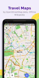
Map view
• Choice of places to be displayed on the map: attractions, food, health and more;
• Search for places by address, name, coordinates, or category;
• Map styles for the convenience of different activities: touring view, nautical map, winter and ski, topographic, desert, off-road, and others;
• Shading relief and plug-in contour lines;
• Ability to overlay different sources of maps on top of each other;
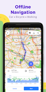
GPS Navigation
• Plotting a route to a place without an Internet connection;
• Customizable navigation profiles for different vehicles: cars, motorcycles, bicycles, 4x4, pedestrians, boats, public transport, and more;
• Change the constructed route, taking into account the exclusion of certain roads or road surfaces;
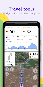
• Customizable information widgets about the route: distance, speed, remaining travel time, distance to turn, and more;
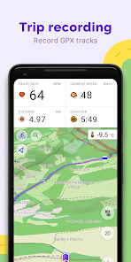
Route Planning and Recording
• Plotting a route point by point using one or multiple navigation profiles;
• Route recording using GPX tracks;
• Manage GPX tracks: displaying your own or imported GPX tracks on the map, navigating through them;
• Visual data about the route - descents/ascents, distances;
• Ability to share GPX track in OpenStreetMap;
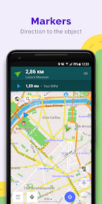
Creation of points with different functionality
• Favourites;
• Markers;
• Audio/video notes;
OpenStreetMap
• Making edits to OSM;
• Updating maps with a frequency of up to one hour;
Additional features
• Compass and radius ruler;
• Mapillary interface;
• Night theme;
• Wikipedia;
• Large community of users around the world, documentation, and support;
Paid features:
Maps+ (in-app or subscription)
• Android Auto support;
• Unlimited map downloads;
• Topo data (Contour lines and Terrain);
• Nautical depths;
• Offline Wikipedia;
• Offline Wikivoyage - Travel guides.
OsmAnd Pro (subscription)
• OsmAnd Cloud (backup and restore);
• Cross-platform;
• Hourly map updates;
• Weather plugin;
• Elevation widget;
• Customise route line;
• External sensors support (ANT+, Bluetooth);
• Online Elevation profile.
OsmAnd is an open source app. We do not collect user data and you decide what data the app will have access to.
Main features:
Map view
• Choice of places to be displayed on the map: attractions, food, health and more;
• Search for places by address, name, coordinates, or category;
• Map styles for the convenience of different activities: touring view, nautical map, winter and ski, topographic, desert, off-road, and others;
• Shading relief and plug-in contour lines;
• Ability to overlay different sources of maps on top of each other;
GPS Navigation
• Plotting a route to a place without an Internet connection;
• Customizable navigation profiles for different vehicles: cars, motorcycles, bicycles, 4x4, pedestrians, boats, public transport, and more;
• Change the constructed route, taking into account the exclusion of certain roads or road surfaces;
• Customizable information widgets about the route: distance, speed, remaining travel time, distance to turn, and more;
Route Planning and Recording
• Plotting a route point by point using one or multiple navigation profiles;
• Route recording using GPX tracks;
• Manage GPX tracks: displaying your own or imported GPX tracks on the map, navigating through them;
• Visual data about the route - descents/ascents, distances;
• Ability to share GPX track in OpenStreetMap;
Creation of points with different functionality
• Favourites;
• Markers;
• Audio/video notes;
OpenStreetMap
• Making edits to OSM;
• Updating maps with a frequency of up to one hour;
Additional features
• Compass and radius ruler;
• Mapillary interface;
• Night theme;
• Wikipedia;
• Large community of users around the world, documentation, and support;
Paid features:
Maps+ (in-app or subscription)
• Android Auto support;
• Unlimited map downloads;
• Topo data (Contour lines and Terrain);
• Nautical depths;
• Offline Wikipedia;
• Offline Wikivoyage - Travel guides.
OsmAnd Pro (subscription)
• OsmAnd Cloud (backup and restore);
• Cross-platform;
• Hourly map updates;
• Weather plugin;
• Elevation widget;
• Customise route line;
• External sensors support (ANT+, Bluetooth);
• Online Elevation profile.
Oxirgi yangilanish
Xavfsizlik — dastur ishlab chiquvchilar maʼlumotlaringizni qanday jamlashi va ulashishini tushunishdan boshlanadi. Maʼlumotlar maxfiyligi va xavfsizlik amaliyotlari ilovadan foydalanish, hudud va yoshga qarab farq qilishi mumkin. Bu axborot dastur ishlab chiquvchi tomonidan taqdim etilgan va keyinchalik yangilanishi mumkin.

Tashqi hamkorlarga hech qanday axborot ulashilmagan
Dastur ishlab chiquvchilar axborot ulashilishini qanday aytishi haqida batafsil

Ushbu ilova quyidagi axborot turlarini toʻplashi mumkin
Men haqimda, Suratlar va videolar va yana 5 ta

Maʼlumotlar uzatish vaqtida shifrlanadi

Maʼlumotlarni oʻchirishni soʻrashingiz mumkin
Reytinglar va sharhlar
4,2
208 ming ta sharh

Gulom Abdualimov
- Nomaqbul deb belgilash
2-avgust, 2025
Zo‘r

Jasurbek Yunusaliyev
- Nomaqbul deb belgilash
8-aprel, 2025
juda ajoyib
1 kishi bu sharhni foydali deb topgan

Abror Yuldashev
- Nomaqbul deb belgilash
11-fevral, 2025
ЖУДА АЖОЙИБ
1 kishi bu sharhni foydali deb topgan
Nima yangiliklar
• Added support for web and cross-platform purchases
• Moved Temperature units to General settings for easier access
• Added battery level indicator for BLE sensors
• New, more intuitive UI for point selection in Navigation
• Improved widget visibility with a new outline
• Added Uphills/Downhills analyzer
• Expanded Wikipedia & Wikivoyage integration for more POIs.
Ilova yuzasidan yordam
Dasturchi haqida


