
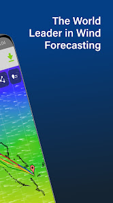
PredictWind Offshore Weather

3,7star
457 ta sharhinfo
50 ming+
Yuklanmalar

3+
info


Bu ilova haqida
The Offshore App allows you to seamlessly download multiple GRIB files for your coastal and offshore passages.
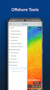
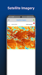
Quickly download and view GRIB files, weather routes, GMDSS maps and text forecasts, AIS data and satellite imagery.
Access all the world’s top ranking forecast models for reliable and accurate weather data, including ECMWF, SPIRE, UKMO, GFS and more. Our very own PWG & PWE models offer incredible accuracy and a record-breaking 1km resolution.
In addition to forecasts, the Offshore App also provides a suite of powerful marine tools to save you time and keep you safe at sea.
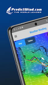
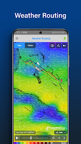
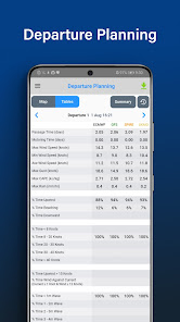
Weather Routing and Departure Planning is calculated in the PredictWind cloud at the highest resolution. The finished route is then sent back to your boat in an incredibly small file size, which is ideal for low bandwidth satellite and SSB connections.
The Offshore App works with Wi-Fi, mobile networks, and most satellite connections using an Iridium GO! exec, Iridium GO!, Globalstar or Optimizer device.
ADDITIONAL FEATURES
GRIB file viewer: High resolution forecasts maps with animated streamlines, wind barbs or arrows.
Tables: The ultimate dashboard for detailed analysis.
Graphs: Compare multiple parameters at the same time.
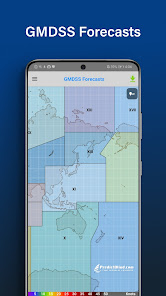
GMDSS Forecasts: View either in the traditional text format or on a map.
Destination Spot Forecast: Know exactly what the weather is doing at your destination.
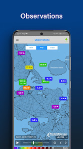
Live Observations: Know what’s happening right now out on the water.
Ocean Data: See what’s happening under the waves with ocean and tidal currents, and sea temperature.
GPS Tracking: Get a free customised GPS tracking page for your blog or website.
AIS Data: View over 280,000 vessels worldwide on the AIS network.
Quickly download and view GRIB files, weather routes, GMDSS maps and text forecasts, AIS data and satellite imagery.
Access all the world’s top ranking forecast models for reliable and accurate weather data, including ECMWF, SPIRE, UKMO, GFS and more. Our very own PWG & PWE models offer incredible accuracy and a record-breaking 1km resolution.
In addition to forecasts, the Offshore App also provides a suite of powerful marine tools to save you time and keep you safe at sea.
Weather Routing and Departure Planning is calculated in the PredictWind cloud at the highest resolution. The finished route is then sent back to your boat in an incredibly small file size, which is ideal for low bandwidth satellite and SSB connections.
The Offshore App works with Wi-Fi, mobile networks, and most satellite connections using an Iridium GO! exec, Iridium GO!, Globalstar or Optimizer device.
ADDITIONAL FEATURES
GRIB file viewer: High resolution forecasts maps with animated streamlines, wind barbs or arrows.
Tables: The ultimate dashboard for detailed analysis.
Graphs: Compare multiple parameters at the same time.
GMDSS Forecasts: View either in the traditional text format or on a map.
Destination Spot Forecast: Know exactly what the weather is doing at your destination.
Live Observations: Know what’s happening right now out on the water.
Ocean Data: See what’s happening under the waves with ocean and tidal currents, and sea temperature.
GPS Tracking: Get a free customised GPS tracking page for your blog or website.
AIS Data: View over 280,000 vessels worldwide on the AIS network.
Oxirgi yangilanish
Xavfsizlik — dastur ishlab chiquvchilar maʼlumotlaringizni qanday jamlashi va ulashishini tushunishdan boshlanadi. Maʼlumotlar maxfiyligi va xavfsizlik amaliyotlari ilovadan foydalanish, hudud va yoshga qarab farq qilishi mumkin. Bu axborot dastur ishlab chiquvchi tomonidan taqdim etilgan va keyinchalik yangilanishi mumkin.

Tashqi hamkorlarga hech qanday axborot ulashilmagan
Dastur ishlab chiquvchilar axborot ulashilishini qanday aytishi haqida batafsil

Hech qanday maʼlumot jamlanmagan
Dastur ishlab chiquvchilar axborot jamlanishini qanday aytishi haqida batafsil

Maʼlumotlar uzatish vaqtida shifrlanadi

Maʼlumotlarni oʻchirishni soʻrashingiz mumkin
Reytinglar va sharhlar
3,7
365 ta sharh
Nima yangiliklar
Changes in v7.5.0.0:
. New map tool tip UI
. New source of Satellite Imagery to replace our old source that is no longer available.
. bugfixes
. New map tool tip UI
. New source of Satellite Imagery to replace our old source that is no longer available.
. bugfixes
Ilova yuzasidan yordam
Dasturchi haqida
PREDICTWIND LIMITED
198 Riverside Ave Point England
Auckland 1072
New Zealand
+64 27 732 6969


