TrekMe - GPS trekking offline
In-app purchases
4.0star
1.04K reviewsinfo
1L+
Downloads

PEGI 3
info


About this app
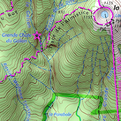
TrekMe is an Android app to get live position on a map and other useful information, without ever needing an internet connection (except when creating a map). It's ideal for trekking, biking, or any outdoor activity.
Your privacy is important as this app has zero tracking. This means you're the only one to know what you do with this app.
In this application, you create a map by chosing the area you want to download. Then, your map is available for offline usage (the GPS works even without mobile data).
Download from USGS, OpenStreetMap, SwissTopo, IGN (France and Spain)
Other topographic map sources will be added.
Fluid and doesn't drain the battery
Particular attention was given to efficency, low battery usage, and smooth experience.
SD card compatible
A large map can be quite heavy and may not fit into your internal memory. If you have an SD card, you can use it.
Features
• Import, record, and share tracks (GPX format)
• Plan your hikes by creating and editing tracks on the map
• Visualize your recording in real time, as well as its statistics (distance, elevation, ..)
• Add markers on the map with optional comments
• See your orientation and speed
• Measure a distance along a track or between two points
Premium features
• Be alerted when you move away from a track, or when you get close to specific locations
• No limit for the size of maps
• Edit existing tracks (extract or remove segment)
• Fix your maps by downloading missing tiles
• Update your maps
• Use the HD version Open Street Map, with a twice better resolution than standard and better readable texts
• France IGN maps with the "IGN option"
..and more
For professionals and enthousiasts
If you have an external GPS with bluetooth*, you can connect it to TrekMe and use it instead of the internal GPS of your device. This is especially useful when your activity (aeronautic, professional topography, ..) requires better precision and updating your position at a higher frequency than every second.
(*) Supports NMEA over bluetooth
Privacy
During a GPX recording, the app collects location data even when the app is closed or not in use. However, your location will never be shared with anyone and gpx files are stored locally on your device.
General TrekMe guide
https://github.com/peterLaurence/TrekMe/blob/master/Readme.md
Updated on
Safety starts with understanding how developers collect and share your data. Data privacy and security practices may vary based on your use, region and age. The developer provided this information and may update it over time.

No data shared with third parties
Learn more about how developers declare sharing

No data collected
Learn more about how developers declare collection
Ratings and reviews
4.0
1.01K reviews

Taras M
- Flag inappropriate
9 November 2021
Just an amazing app, if it's free maps are enough for you. It let's you download maps for area, and allows you to specify zoom levels, which can save some 80% of space! (I chose only the closest zoom levels, for example). Custom treks work great, and are fully customizeable, gps is also good. The app itself is super lightweight and responsive.
83 people found this review helpful
Pierre Laurence
10 November 2021
Thank you very much!

Karsten Keese
- Flag inappropriate
11 June 2023
It is not possible to acquire the extended version once and for all, only to rent it by paying recurring subscription fees ad infinitum. In light of the fact that there are competitor products out there that can be bought instead of rented, this milkingware has been replaced with a functionally superior alternative and is consequently being uninstalled as we speak.
40 people found this review helpful

Jamie 5301
- Flag inappropriate
9 May 2023
Brilliant for France, limited use in UK. IGN make their maps available free-of-charge and a 40km x 40km square can be downloaded into only 300 MB of storage, and that's a super-detailed map that will zoom in to a scale of 1:15000 so shows all the farm tracks. Brilliant value at GBP 13.99 for a year. Doesn't access the OSMaps with footpaths, only the v basic OS maps, so for UK walkers it's best to stick with the OSMaps app and subscription (GBP23.99 pa)
39 people found this review helpful
What's new
4.14.1
• New: import and copy marker location to clipboard.
• Redesign and simplify area selection in map creation.
• Improve how latitude and longitude are displayed for markers.
4.13.x
• Redesign map list
• New premium feature: extract or remove a segment of a track.
• Various fixes
4.12.0
• Added search by name in "manage tracks" screen, in each map.
App support
About the developer


