
Magic Earth Navigation & Maps
4.3star
38.5K reviewsinfo
1M+
Downloads

PEGI 3
info

About this app
Find the best route to your destination even without an internet connection. Magic Earth uses OpenStreetMap data and a powerful search engine to offer you the optimal routes for driving, biking, hiking and public transportation.
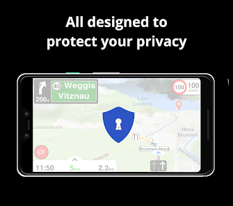
PRIVACY FIRST!
• We do not track you. We do not profile you. We do not trade in your personal data; moreover, we do not have it.
MAPS
• Save big on mobile internet costs and navigate reliably with offline maps powered by OpenStreetMap. 233 countries and regions are ready to be downloaded.
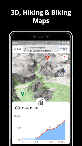
• Choose between 2D, 3D and Satellite map views.
• Get ready for travel and know every detail of your route like surface, difficulty, distance and elevation profile.
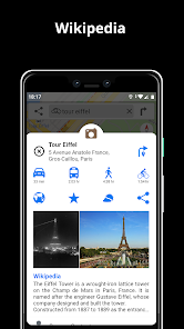
• Learn more about the points of interest near you from Wikipedia articles.
• Spot nearby parking places to easily park your car.
• Stay up-to-date and enjoy regular free map updates.
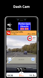
AI DASHCAM
• Improve safe driving and avoid accidents. Receive alerts to potential problems on the road and record your trip.
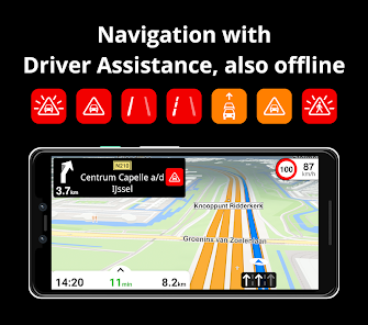
• AI DashCam features Driver Assistance warnings and Dash Cam functionality.
• Avoid collisions and accidents with Driver Assistance warnings: Headway Warning, Forward Collision Warning, Pedestrian Collision Warning, Lane Departure Warning, Leaving Lane Warning, Stop & Go Assist.
• Record the road ahead during navigation to have an aid in the event of a collision or incident.
• Driver Assistance warnings and Recordings are available when the device is on a car mount in landscape mode, with a clear view of the road ahead.
* AI DashCam (with Driver Assistance warnings and Dash Cam functionality) requires Android 7 or later.
NAVIGATION
• Find the fastest or the shortest route to your destination when you travel by car, bike, on foot or with public transport.
• Plan your route with multiple waypoints.
• Stay safe with the free Head-up Display (HUD) feature which projects the most important navigation info onto the windshield of your car.
• Know in advance which lane to take with precise turn-by-turn navigation and lane assistance.
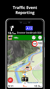
• Get notified about speed cameras and stay up to date with current speed limits.
TRAFFIC INFO
• Get real-time traffic info, updated every minute.
• Discover alternative routes that avoid the traffic jams and save you time on the road.
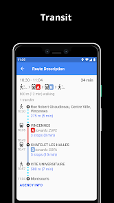
PUBLIC TRANSPORT
• Get around town quickly and easily. Choose from public transit routes that combine all transportation modes: bus / metro / subway / light rail / train / ferry
• Get walking directions, transfer times, departure times, number of stops. And when available, the cost.
• Find wheelchair or bike friendly public transportation.
WEATHER
• View current temperature and local weather forecast for your favorite locations.
• See what weather conditions to expect in the next hours and view the forecast for the next 10 days.
NOTES:
* Some features are not available in all countries.
* Some features require internet connection.
PRIVACY FIRST!
• We do not track you. We do not profile you. We do not trade in your personal data; moreover, we do not have it.
MAPS
• Save big on mobile internet costs and navigate reliably with offline maps powered by OpenStreetMap. 233 countries and regions are ready to be downloaded.
• Choose between 2D, 3D and Satellite map views.
• Get ready for travel and know every detail of your route like surface, difficulty, distance and elevation profile.
• Learn more about the points of interest near you from Wikipedia articles.
• Spot nearby parking places to easily park your car.
• Stay up-to-date and enjoy regular free map updates.
AI DASHCAM
• Improve safe driving and avoid accidents. Receive alerts to potential problems on the road and record your trip.
• AI DashCam features Driver Assistance warnings and Dash Cam functionality.
• Avoid collisions and accidents with Driver Assistance warnings: Headway Warning, Forward Collision Warning, Pedestrian Collision Warning, Lane Departure Warning, Leaving Lane Warning, Stop & Go Assist.
• Record the road ahead during navigation to have an aid in the event of a collision or incident.
• Driver Assistance warnings and Recordings are available when the device is on a car mount in landscape mode, with a clear view of the road ahead.
* AI DashCam (with Driver Assistance warnings and Dash Cam functionality) requires Android 7 or later.
NAVIGATION
• Find the fastest or the shortest route to your destination when you travel by car, bike, on foot or with public transport.
• Plan your route with multiple waypoints.
• Stay safe with the free Head-up Display (HUD) feature which projects the most important navigation info onto the windshield of your car.
• Know in advance which lane to take with precise turn-by-turn navigation and lane assistance.
• Get notified about speed cameras and stay up to date with current speed limits.
TRAFFIC INFO
• Get real-time traffic info, updated every minute.
• Discover alternative routes that avoid the traffic jams and save you time on the road.
PUBLIC TRANSPORT
• Get around town quickly and easily. Choose from public transit routes that combine all transportation modes: bus / metro / subway / light rail / train / ferry
• Get walking directions, transfer times, departure times, number of stops. And when available, the cost.
• Find wheelchair or bike friendly public transportation.
WEATHER
• View current temperature and local weather forecast for your favorite locations.
• See what weather conditions to expect in the next hours and view the forecast for the next 10 days.
NOTES:
* Some features are not available in all countries.
* Some features require internet connection.
Updated on
Safety starts with understanding how developers collect and share your data. Data privacy and security practices may vary based on your use, region, and age. The developer provided this information and may update it over time.


Ratings and reviews
4.3
35.8K reviews

Krystian Różycki
- Flag inappropriate
May 13, 2025
It seemed interesting because of the multitude of options. But the longer I use it, the more I see its shortcomings. First of all, there is no flat map display mode. There is always this quasi-3D view. You can't click on a place on the map and navigate to that place. And the saddest thing is that the application does not save GPS tracks in GPX files. It supposedly saves them, but after saving, these files are nowhere to be found in the smartphone's memory or on the SD card. It has a lot to fix.
5 people found this review helpful
Magic Lane International B.V.
June 5, 2025
Flat mode is activated if you drag down with 2 fingers and if Settings → Navigation → 2D/3D Map is set to 2D. You can click on a place, drag up the menu that appears below and press on a vehicle profile (car/truck etc). The route will be calculated and you can start navigation. You can share GPX tracks by tapping Search Bar → GPX Tracks → Share

Tyron Robinson
- Flag inappropriate
April 10, 2025
magic earth solved a no-voice issue I was having with the two mainstream nav apps by enabling it's directions to be played over Bluetooth as a phonecall 👌🏻 ( allowing seperate volume control to the media and almost no delays in information) , the map features are nicely customisable and the appearance is nice and clean with house numbers etc, I haven't used the large vehicle feature yet but soon I'll test it towing a large van 6000klm+
24 people found this review helpful
Magic Lane International B.V.
April 10, 2025
Thank you very much for your 5-star review! We’re constantly working on improving and adding new functionality to make the app better for all users.

Hassan Alzoubi
- Flag inappropriate
February 10, 2025
Since I started using this program, its developments have been great, such as adding ,a Dash cam, and then adding audio recording, which made it unique. I hope this program will flourish, as it is wonderful. something I hope will be added to.. as 1-warnings or directions for a period of no less than a 2 minutes, so we can take the appropriate action, sometimes we miss the road. 2-allows adding more than 3 places to the path, as in other pro maap, it allows 7. All respect and appreciation
12 people found this review helpful
Magic Lane International B.V.
June 27, 2019
Hi, Hassan and thank you for rating Magic Earth 5 stars! Enjoy your travels with the app and feel free to contact us if you ever need our assistance.
What’s new
Bugs fixing and stability improvements
App support
About the developer
Magic Lane International B.V.
Narva-eiland 52
1014 ZJ Amsterdam
Netherlands
+40 744 494 824


