Angle Meter
Περιέχει διαφημίσεις
4,7star
5,73 χιλ. κριτικέςinfo
1 εκ.+
Λήψεις

PEGI 3
info


Περιγραφή εφαρμογής
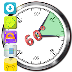
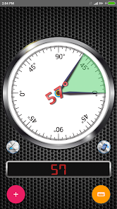
Γωνιακός μετρητής
Η εφαρμογή γωνιακού μετρητή είναι ένα εργαλείο μέτρησης γωνίας ή κλίσης. Χρησιμοποιεί εφαπτομένη τόξου βαρύτητας μεταξύ δύο αξόνων και παρέχει ακριβή αποτελέσματα ανάλογα με την ποιότητα των αισθητήρων.
Χαρακτηριστικά
• Επιλογή για μέτρηση γωνίας ή κλίσης σε επιφάνειες που δεν είναι παράλληλες προς τη γείωση με λειτουργία σχετικής γωνίας.
• Διάστημα 0-180 ή 0-360 μοίρες με γωνιακό συμπλήρωμα.
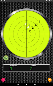
• 2 άξονες προσανατολισμού (Μετακινήστε τη συσκευή σας αριστερά / δεξιά ή προς τα πίσω / προς τα εμπρός)
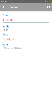
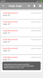
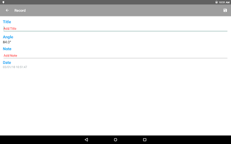
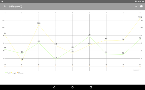
• Επιλογή αποθήκευσης εγγραφών στη βάση δεδομένων, προβολή τους ως λίστες ή διαγράμματα και λήψη αντιγράφου του ιστορικού μέτρησης (ως xls αρχεία ή διαγράμματα).
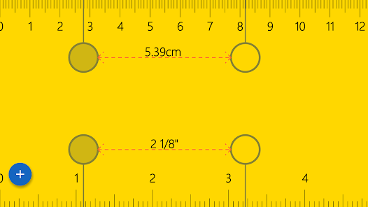
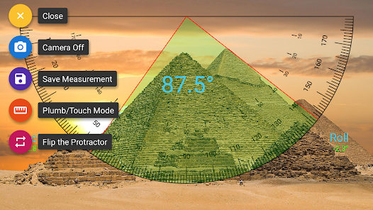
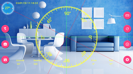
• Επιλογή μέτρησης της γωνίας ενός αντικειμένου στην εικόνα μέσω της οθόνης μέτρησης εικόνας.
• Γκαλερί εικόνων για προβολή εικόνων σε λειτουργία προεπισκόπησης ή με λεπτομέρειες.
• Διάφορες επιλογές προσαρμογής.
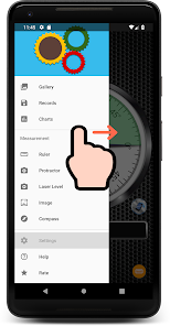
Οδηγίες
💡 - Το Εγχειρίδιο Χρήσης και η Πολιτική Απορρήτου διατίθενται στην ενότητα Βοήθεια της προβολής πλοήγησης.
⚠️ - Για να ανοίξετε την προβολή πλοήγησης, σύρετε την οθόνη σας προς τα δεξιά δίπλα στην αριστερή πλευρά της οθόνης.
⚙ - Για επιλογές προσαρμογής, επισκεφθείτε την οθόνη Ρυθμίσεις.
📧 - Εάν χρειάζεστε περισσότερες λεπτομέρειες σχετικά με τη χρήση αυτής της εφαρμογής ή έχετε την πρόθεση να κάνετε αυτήν την εφαρμογή καλύτερα μην διστάσετε να στείλετε μήνυμα ηλεκτρονικού ταχυδρομείου ανά πάσα στιγμή.
Μέθοδοι μέτρησης 🛠🛠🛠
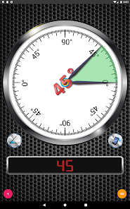
Ενιαία γωνία: Περιστρέψτε τη συσκευή σας και διαβάστε τη γωνία.
Διαφορά μεταξύ δύο γωνιών: Αυτή η λειτουργία είναι χρήσιμη για τον υπολογισμό της κλίσης μεταξύ 2 ξεχωριστών αντικειμένων. Αφαιρέστε τη γωνία του μετρητή γωνιών και στερεώστε την πρώτη γωνία. Αγγίξτε ξανά για να διορθώσετε το δεύτερο και δείτε τη διαφορά μεταξύ γωνιών.
Σχετική γωνία: Αυτή η λειτουργία είναι χρήσιμη για τη μέτρηση της γωνίας αν το αντικείμενο δεν είναι παράλληλο προς το έδαφος ή η επιφάνεια δεν είναι ομοιόμορφη. Αγγίξτε το πλαίσιο του μετρητή γωνίας για να ρυθμίσετε το πρώτο τμήμα της γωνίας, αγγίξτε ξανά μετά την περιστροφή της συσκευής σας για να ολοκληρώσετε τη μέτρηση.
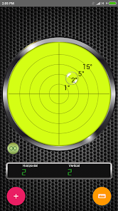
Επίπεδο φούσκας: Βάλτε τη συσκευή σας στο πάτωμα και μετρήστε τη γωνία γείωσης οριζόντια και κάθετα.
Ικανοποίηση και ανταπόκριση πελατών
⚠️ ΣΗΜΑΝΤΙΚΟ: Αν βρείτε κάποιο σφάλμα χρησιμοποιώντας την εφαρμογή, PLEASE γράψτε στο [email protected] με το όνομα του μοντέλου του τηλεφώνου σας και την περιγραφή του προβλήματος πριν γράψετε ένα αρνητικό σχόλιο.
🤝 ✅ 👍 Η ικανοποίηση του πελάτη είναι προτεραιότητα μας και θα κάνουμε το καλύτερο δυνατό για να διορθώσουμε τα θέματα το συντομότερο δυνατό! Σας ευχαριστούμε που επιλέξατε αυτήν την εφαρμογή.
• Επιλογή για μέτρηση γωνίας ή κλίσης σε επιφάνειες που δεν είναι παράλληλες προς τη γείωση με λειτουργία σχετικής γωνίας.
• Διάστημα 0-180 ή 0-360 μοίρες με γωνιακό συμπλήρωμα.
• 2 άξονες προσανατολισμού (Μετακινήστε τη συσκευή σας αριστερά / δεξιά ή προς τα πίσω / προς τα εμπρός)
• Επιλογή αποθήκευσης εγγραφών στη βάση δεδομένων, προβολή τους ως λίστες ή διαγράμματα και λήψη αντιγράφου του ιστορικού μέτρησης (ως xls αρχεία ή διαγράμματα).
• Επιλογή μέτρησης της γωνίας ενός αντικειμένου στην εικόνα μέσω της οθόνης μέτρησης εικόνας.
• Γκαλερί εικόνων για προβολή εικόνων σε λειτουργία προεπισκόπησης ή με λεπτομέρειες.
• Διάφορες επιλογές προσαρμογής.
Οδηγίες
💡 - Το Εγχειρίδιο Χρήσης και η Πολιτική Απορρήτου διατίθενται στην ενότητα Βοήθεια της προβολής πλοήγησης.
⚠️ - Για να ανοίξετε την προβολή πλοήγησης, σύρετε την οθόνη σας προς τα δεξιά δίπλα στην αριστερή πλευρά της οθόνης.
⚙ - Για επιλογές προσαρμογής, επισκεφθείτε την οθόνη Ρυθμίσεις.
📧 - Εάν χρειάζεστε περισσότερες λεπτομέρειες σχετικά με τη χρήση αυτής της εφαρμογής ή έχετε την πρόθεση να κάνετε αυτήν την εφαρμογή καλύτερα μην διστάσετε να στείλετε μήνυμα ηλεκτρονικού ταχυδρομείου ανά πάσα στιγμή.
Μέθοδοι μέτρησης 🛠🛠🛠
Ενιαία γωνία: Περιστρέψτε τη συσκευή σας και διαβάστε τη γωνία.
Διαφορά μεταξύ δύο γωνιών: Αυτή η λειτουργία είναι χρήσιμη για τον υπολογισμό της κλίσης μεταξύ 2 ξεχωριστών αντικειμένων. Αφαιρέστε τη γωνία του μετρητή γωνιών και στερεώστε την πρώτη γωνία. Αγγίξτε ξανά για να διορθώσετε το δεύτερο και δείτε τη διαφορά μεταξύ γωνιών.
Σχετική γωνία: Αυτή η λειτουργία είναι χρήσιμη για τη μέτρηση της γωνίας αν το αντικείμενο δεν είναι παράλληλο προς το έδαφος ή η επιφάνεια δεν είναι ομοιόμορφη. Αγγίξτε το πλαίσιο του μετρητή γωνίας για να ρυθμίσετε το πρώτο τμήμα της γωνίας, αγγίξτε ξανά μετά την περιστροφή της συσκευής σας για να ολοκληρώσετε τη μέτρηση.
Επίπεδο φούσκας: Βάλτε τη συσκευή σας στο πάτωμα και μετρήστε τη γωνία γείωσης οριζόντια και κάθετα.
Ικανοποίηση και ανταπόκριση πελατών
⚠️ ΣΗΜΑΝΤΙΚΟ: Αν βρείτε κάποιο σφάλμα χρησιμοποιώντας την εφαρμογή, PLEASE γράψτε στο [email protected] με το όνομα του μοντέλου του τηλεφώνου σας και την περιγραφή του προβλήματος πριν γράψετε ένα αρνητικό σχόλιο.
🤝 ✅ 👍 Η ικανοποίηση του πελάτη είναι προτεραιότητα μας και θα κάνουμε το καλύτερο δυνατό για να διορθώσουμε τα θέματα το συντομότερο δυνατό! Σας ευχαριστούμε που επιλέξατε αυτήν την εφαρμογή.
Ενημερώθηκε στις
Η ασφάλειά σας ξεκινά από την κατανόηση του τρόπου με τον οποίο οι προγραμματιστές συλλέγουν και κοινοποιούν τα δεδομένα σας. Οι πρακτικές απορρήτου και ασφάλειας δεδομένων μπορεί να διαφέρουν ανάλογα με τη χρήση, την περιοχή και την ηλικία σας. Αυτές οι πληροφορίες παρέχονται από τον προγραμματιστή και ενδέχεται να ενημερωθούν με την πάροδο του χρόνου.

Αυτή η εφαρμογή ενδέχεται να κοινοποιεί αυτούς τους τύπους δεδομένων σε τρίτα μέρη
Τοποθεσία, Δραστηριότητα σε εφαρμογές και 2 ακόμη

Αυτή η εφαρμογή ενδέχεται να συλλέγει αυτούς τους τύπους δεδομένων
Τοποθεσία, Δραστηριότητα σε εφαρμογές και 2 ακόμη

Τα δεδομένα κρυπτογραφούνται κατά τη μεταφορά

Δεν είναι δυνατή η διαγραφή δεδομένων
Βαθμολογίες και αξιολογήσεις
4,7
5,65 χιλ. αξιολογήσεις

ΧΡΙΣΤΙΝΑ ΚΡΑ
- Επισήμανση ως ακατάλληλης
29 Ιουλίου 2021
ΤΕΛΕΙΟ!!!
1 άτομο βρήκε χρήσιμη αυτή την κριτική

Ioannis Galionis
- Επισήμανση ως ακατάλληλης
- Προβολή ιστορικού κριτικής
15 Ιουνίου 2020
Excellent application. I have used the laser level feature a lot, comparing the measurements with other tools and the results are quite accurate. It is possible though to save the GPS coordinates in the images' properties?
1 άτομο βρήκε χρήσιμη αυτή την κριτική

FRAGKISKOS FRERHS
- Επισήμανση ως ακατάλληλης
2 Ιουλίου 2020
Perfect
3 άτομα βρήκαν χρήσιμη αυτή την κριτική
Τι νέο υπάρχει
Crash Fix
Υποστήριξη εφαρμογής
Σχετικά με τον προγραμματιστή
Fatih Özcan
Erikli Köyü Erikli Mah Erikli Caddesi
No:40 B_Cumhuriyet Sitesi
22800 Keşan/Edirne
Türkiye
undefined


